Print This Page>

Cameron Highlands: Jungle Trekking Trails
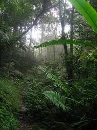
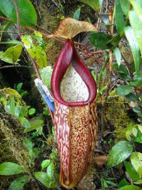
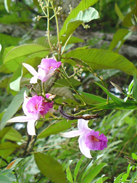
Cameron Highlands jungle a great place to hang out for nature worship and just walk for exercise, take an early morning stroll to find pitcher plants, wild orchids, funky fungi, tree-bound epiphytes, huge tree ferns and lipstick plants.
Birders can linger to look for over 70 species of montane rainforest birds like trogons, whistling thrushes, and forktails. Search for tracks of the rare clouded leopard or black panther, be aware of poisonous pit viper snakes, watch for green lizards and catch a glimpse of a civet.
Before start your jounery of jungle trekking please prepare following things:
1.Water-Water is very necessary to bring sufficient amount to quench your thirst.
(Bring plenty of it as you possibly could because water is heavy)
2.Food-Food will give you some energy and some for emergencies.
3.Mobile hand phone-To call for help. Don't forget to bring hotel number and local emergency numbers.(Make sure batterly is fully charge)
4.Pieces of paper and pen-Good for marking trails.
5.Torches-Give you a light when turn to night.
6.Knife-useful in survival situation
7.Medication-Would be helpful.
8.Lighter-To make fire at night.(Good for making smoke help signal)
| Trails |
Rating |
Field Notes |
| Trail 1 |
Tough |
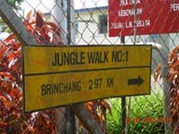
A climb up to Gunung Brinchang (2032 meters) starting north of Brinchang town; over 1-hour walk up with another hour walk back on road; alternatively drive to summit and walk down Trail 1; another option is to trek back and forth on part of the dense mossy forest ridge trail to Gunung Irau (2090 meters) that takes 3-4 hours one-way; all trails not well marked; use a guide. |
| Trail 2 |
Tough |
Need to be fit and prepared for this 1.5 hour up and down walk over rough terrain; not well marked and merges with Trail 3 for a longer trek; starts in Brinchang at Sam Poh Buddhist Temple |
| Trail 3 |
Moderate to Tough |
Starts at Arcadia Cottage near the golf course; a 2.5 hour steep climb to Gunung Beremban (1841 meters); shorter alternate paths to Trail 2 and Trail 5; longer treks join Trail 7 or Trail 8 from atop the mountain (allow 2 more hours) |
| Trail 4 |
Easy |
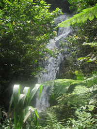
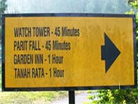
A 30-minute stroll to Parit Waterfall, the path is paved in stretches with a turnoff to the watchtower; start near the Forestry Department |
| Trail 5 |
Easy to Moderate |
A 1-hour walk over wooded terrain that merges with Trail 3 to split off towards Gunung Beremban or to Arcadia Cottage, with the option to shift to Trail 2 to Sam Poh Temple; start at MARDI (Malaysian Agriculture Research and Development Institute) |
| Trail 6 |
Moderate to Tough |
A poorly marked and confusing path that starts at Bharat Tea Estate road, continues along ridge and merges with Trail 10 at Gunung Jasar summit (1670 meters); 2.5 hours but easy to get lost so use a guide; do not be confused by another Trail 6 runs short from Parit Waterfall to join Trail 5 |
| Trail 7 |
Very Tough |
A 2-hour haul starting from MARDI with a steep ascent to Gunung Beremban on overgrown path; descend from the top on Trail 3 (recommended) or hike down Trail 8 for another 2-3 hour adventure |
| Trail 8 |
Very Tough |
A difficult 3-hour climb starting from Robinson Waterfall to Gunung Beremban |
| Trail 9 |
Moderate |
A 1-hour hike down from Robinson Waterfall to the power station following pipeline on a slightly steep descent with some difficult scrambling; alternatively walk down Trail 9A and return up via this path (2 hours) or take a local bus back to Tanah Rata. |
| Trail 9A |
Moderate |
Less steep than Trail 9 along a gradual path that exits near vegetable farms and the Boh Tea Plantation road after 1.5 to 2 hours; alternatively walk up Trail 9 behind the power station or take a local bus back to Tanah Rata |
| Trail 10,11&12 |
Moderate to Tough |
An arduous climb up to Gunung Jasar, the path starts near Oly Apartments and continues towards Gunung Perdah (1551 meters); to avoid the summit splinter off to Trail 11 along a parallel path to Gunung Perdah where both trails merge with Trail 12 to the weather station near the golf course road; unclear on markings and time estimates; Trail 12 also leads down to exit out of the Orang Asli village with a walk back by road or straight back via Dahlia Villa |
| Trail 13 |
Moderate |
Start behind Cameronian Holiday Inn for a 1.5 hour walk with a stream that merges with Trail 14 |
| Trail 14 |
Moderate |
A good day hike to experience enclosed, mossy forests on way to Gunung Mentigi (1535 meters) before exiting on the Tanah Rata road; return via local bus; may need a guide and can last up to 4 hours |
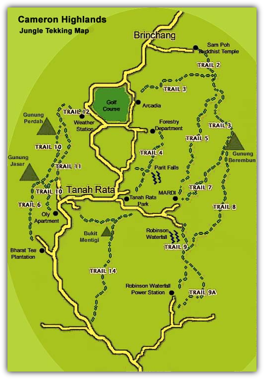
Cameron Highlands: Jungle Trekking Trails Map
| Trail |
Wild Features & Photography Options |
| Trail 1 |
highest peak G. Brinchang; excellent mossy forest; pitcher plants, orchids, fungi; birdwatching |
| Trail 2 |
birdwatching; small stream; millipedes; moss, pitcher plants, orchids |
| Trail 3 |
vistas of Tanah Rata; monkeys; birdwatching; gingers |
| Trail 4 |
steep trail to watchtower with panoramic views; ferns, gingers |
| Trail 5 |
secondary forest; stream; snakes, millipedes; bird's nest fern, palms |
| Trail 6 |
scenery of G. Jasar; Orang Asli village |
| Trail 7 |
secondary forest; rattan, ferns, orchids, palms |
| Trail 8 |
Robinson Waterfall; forest scenery |
| Trail 9 |
birdwatching; lizards; frogs; squirrels; Robinson Waterfall; fungi, ferns, orchids, gingers, lianas |
| Trail 10, 11 & 12 |
panoramic views; Orang Asli village; butterflies; flowers, wild pepper |
| Trail 13 |
small river; tree ferns; mossy forest |
| Trail 14 |
mossy forest; lianas; historical war remnants |
On each trail you can find interesting plants and animals or observe rainforest birds or beautiful orchids. Take a pair of binoculars or a camera and linger among the fungi, mossy forest and monkeys to capture a glimpse of these diverse habitats.
Welcome to
Cameron Highlands
Jungle Trekking Trails Guide Page